Available editions include: 1884, 1890, 1893, 1899, 1903, 1910, 1913, and 1924. Also posted is the Insurance Plan of the City of Toronto for the years 1880 and 1889, as well as a special article on the Toronto Fires of 1904 and 1895.
[See also my companion map site: Historical Maps of Toronto. Highlights include the 1858 Boulton Atlas and the 1842 Cane Topological Map of the City.]
My intent for this project was to crudely mimic the well-known reference work, The Mapping of Victorian Toronto: the 1884 & 1890 Atlases of Toronto in Comparative Rendition. Used prints of the latter are occasionally available for about $400; an original Goad’s Atlas (2nd Ed.) was recently listed for $6,500.
This version is free.
Images courtesy of Toronto Public Library, Library and Archives Canada, and City of Toronto Archives.
Click the mini-maps below, to start exploring!
For best results, use an adequate display: 1400x900 or larger is highly recommended.
 |
| Click this map to browse the 1884 Goad Atlas of the City of Toronto! |
 |
| Click to view the 1890 Atlas of Toronto (2nd ed.) |
 |
| Click to view the 1893 Atlas of Toronto |
 |
| Click to view the 1899 Atlas of Toronto |
 |
| Click to view the 1903 Atlas of Toronto |
 |
| Click to view the 1910 Atlas of Toronto (3rd ed.) |
 |
| Click to view the 1913 Atlas of Toronto |
 |
| Click to view the 1924 Atlas of Toronto |
Special Bonus Updates:
 |
| Bonus 1: Click to view the 1880 Insurance Plan |
 |
| Bonus 2: Click to view the 1889 Insurance Plan |
 |
| Bonus 3: The Great Toronto Fires of 1904 -- and 1895 |
 |
| Extra Special Bonus: 1858 Boulton Atlas of Toronto See Also: 1842 Cane Topographical Map of the City and Liberties of Toronto |
The History of Charles Goad’s Fire Insurance Plans
 |
| Charles E. Goad |
His Chas. E. Goad Company held a quasi-monopoly on this business in the late 1800s, ultimately surveying over 1,300 communities across Canada, as well as around the world -- including the United Kingdom, France and Mexico.
Researchers delving into the history of buildings in Toronto inevitably wind up scrutinizing and comparing the various extant editions of the ‘Goad fire insurance maps’. By examining the differences between revisions, historians can roughly tell: when a given structure was built (or demolished), what it was made of, its placement in relation to other buildings, and even its shape.
 |
| 1889 Goad Plan Key |
The maps had to be frequently updated in order to remain current -- a daunting task when surveying a rapidly expanding community such as Victorian-era Toronto. Instead of printing new copies, revisions took the form of paper stickers, which were overlaid on top of the maps!
The expense and effort of producing the large-format, colored atlases usually meant that few copies were printed. Many archival instances originate from customers who failed to return or destroy their copies.
Describing the Goad maps for BlogTO, Derek Flack writes,
“With its identification of buildings both big and small, Goad’s Atlas operates like a proto-Google Satellite map, where the viewer can get a sense for the urban environment on a street by street basis rather than just in a macro capacity. For the contemporary map-reader, this level of detail underscores just how much the city has changed in the last century.”Along with his surveyors, Charles E. Goad gained a unique first-hand knowledge of Toronto that went far beyond that of anyone else -- ever -- during the process of relentlessly combing through each and every street in our burgeoning city.
My first Goad Atlas encounter
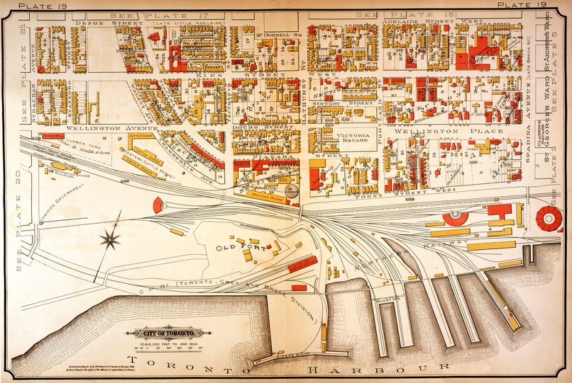
I first stumbled across the Goad Atlases during my research into the history of the recently-demolished Doty Engine Works at the corner of Front and Bathurst.I was fascinated by Goad’s colourful depiction of the built fabric of Toronto during the late 1800s. The neigbourhood I was investigating looked like this:
 |
| 1884 Goad Atlas of Toronto - Plate 19 Observe, for example, what happens at the corner of Front and Bathurst... (Click maps to expand) |
I marvelled at the evolution, over time, of the character of the streets, and at the heavy influence of the railway south of Front Street. Not to mention -- the maps are beautiful to behold.
 |
| 1890 Goad Atlas of Toronto - Plate 19 (This is the Toronto Archives’ lurid scan) Comparing editions allows you to identify changes taking place in the neighbourhood |
 |
| 1893 Goad Atlas of Toronto - Plate 19 See the crooked overlay on the Doty Engine Works? |
Discover the past of your own Toronto neighbourhood, through a similar examination -- it’s just a few clicks away. Revelatory insights into the history of our city’s development await you.
It does make you wonder -- one day perhaps, 100 years from now -- and 200 years after Charles Goad’s systematic peregrinations through our lanes and byways -- will amateur historians sleuth endlessly through rescued Google Street View database backups, trying to decipher our contemporary urban architecture?
Please ‘Like’, share, link, or forward this post. I hope that other Toronto heritage enthusiasts will find it useful. Have fun exploring Victorian Toronto!
------------------------------------------------------------------------------------
Extended Discussion: Why I put these maps online
The value-add for this project is not the content, which is already available online, through other sources. It’s the complementary provision of that content via an effective (albeit rudimentary) interface that allows anyone to quickly identify, and access specific plates from the Goad Atlases. |
| An update sticker from the 1889 Goad Insurance Plan of Toronto: tracking which revisions had been applied to a given copy -- this plan was printed in 1880, and has five sets of updates applied to it, up to August 1889 |
Online Frustration
I was dissatisfied with the existing modes for browsing the Atlases. Nothing ever compares to leisurely peering at a fragile copy in person -- but online access is often more convenient.
Not surprisingly, the City of Toronto Archives offers a fine selection of Goad maps through their website.
Sadly, the images are trapped inside an arcane, patent-encumbered file format that requires the installation of either: an obscure third-party extension -- compatible only with long-obsolete versions of Internet Explorer or Firefox (c’mon, be serious -- Firefox 2?!) -- or a closed-source, commercial application. The sole available developer has also chosen not to support the Linux or OS X platforms, going so far as to remove older versions of software that previously worked.
 |
| ‘Install this crappy 3rd-party extension onto your ancient browser version that has been phased out. And that’s if you have that specific browser, for that particular operating system.’ Umm... |
If you’re nevertheless able to setup a Windows system and install the extension, you’ll then discover that the user interface to handle the images is pathetic. It’s awkward, and kludgy -- a reliving of terrible 1990s UI that will make you gnash your teeth in aggravation.
I will concede that the Archives’ scans do have a vibrant, almost lurid quality to them that accentuates the age of the source material (see Plate 19 scan for 1890 above for example)...
Meanwhile, the Toronto Public Library also provides Goad maps via the Internet -- but the catalogue fails to display the plates in any useful order, or with sufficient identifying information. You can sort everything by year, but you can’t sort -- or view -- plate numbers on the catalogue thumbnails, or in the titles -- which forces you to load each individual entry!
Further, the thumbnails are much too small and fuzzy for my near-sighted eyes. Again, a miserable experience -- nothing’s quite like sifting through 300 entries to find a desired plate...
 |
| Excerpted sample TPL catalogue search results. Can you distinguish which plate is which? I can’t. Results shown here are, in date-sorted order: Plates 19, 13, 17, and 29 from 1884. Sigh. |
A brief hands-on exercise will illustrate my point. I defy you to unearth plate 59 from the 1889 edition of the Insurance Plan of Toronto -- that’s the section covering King and Bathurst -- out of the TPL catalogue. Just try it. I’ll even award a special prize to the first reader to successfully send me the file. I can wait...
[Update May 9, 2012: It turns out there is a secret ninja cataloguer method to directly search for specific plates. In this TPL local history blog post (which happens to link to this site as an ‘Additional Source’!), I discovered:
If you know the Plate Number, enter the year of the atlas and the Plate Number preceded by two zeros e.g. goad toronto 1884 0025Cool!! But it’s too late for me, I’ve already put up this site! Haha. Note that you still won’t be able to find plate 59 above even if you try this method...]
Finally, Library and Archives Canada has an online collection of Goad maps and materials (see links at bottom of post) -- but you may only navigate linearly through five plate thumbnails at a time -- and you must start at the beginning -- which entails a tedious, interminable slog to locate the plate you want -- and that’s if you know the plate number.
 |
| Library and Archives Canada website: Great scans; painful navigation. |
For anyone trying to access these glorious maps from home, this situation is lousy. A century after Charles Goad left us, the most effective method of accessing his work remains leafing through a physical copy at the Reference Library!
I was inspired by the example of W. Xavier Snelgrove, who, encountering the issues identified above at the Archives (for a different resource), reacted by extracting and posting a set of Toronto maps which will be immediately familiar to anyone who has gone to the Archives, or visited the 4th floor of the Toronto Reference Library.
The summary benefit: Simple navigation to the plates you want. A solution that works with any major browser on any platform; no special extra software required. It’s the way the Archives website should work -- if you didn’t have to wrestle with that idiotic software extension.
 |
| The ‘Island of Hiawatha’ in 1893 (Plate 30) See Hanlan’s Hotel on Gibraltar Point. And Ward’s on the other end! |
What I’ve Done, and Future Ideas
I downloaded all of the Toronto Atlas plate images for 1884, 1890, 1893, 1899, 1903, and 1910, as well as the 1889/1892 Insurance Plan of Toronto, from the public domain scans posted by the Toronto Public Library and Library and Archives Canada. I then re-uploaded the images -- untouched and at full-resolution -- and linked them all. Straightforward, unsophisticated work.This website may be considered as a digital alternative to The Mapping of Victorian Toronto. The latter does not show all the plates in colour (a real shame); nor does it include 1893, 1899, 1903 or 1910 (though it does have a solid introduction by Lucy Booth Martyn). Comparing plates online is simple -- open the same plate for different years, in adjoining tabs.
Should you find any linking errors, or historical inaccuracies -- let me know in the comments. Setting up the links was monotonous (does anyone enjoy creating image-maps in HTML?) so there is a distinct possibility of minor gaffes...
Cleaner, less-clumsy methods of presentation certainly exist. I settled on the most efficient and direct approach available to me involving the least work.
I welcome -- in fact I challenge readers to contemplate -- a jazzed-up, interactive version, or a gigantic ‘all in one file’ image carefully stitched together (which, alas, is problematic due to varying map scales). Or perhaps some kind of modern-day overlay/comparison tool... How about a location-aware iPad app that contextually displays where you are, on the map? etc.
With this spirit in mind, I’ve placed all of the Goad images I’ve liberated onto Dropbox for easy download: 1884, 1890, 1893, 1899. Bonus: 1889 Insurance Plan; 1903 Atlas, 1910 Atlas. Don’t want to rely on my website or a fickle internet connection? No problem! Download the files for yourself, and enjoy your own local archive.
 |
| A wealth of fascinating details abide in Plate 3 from the 1884 edition, e.g.: The waterfront was much farther north... Union Station was still in its second incarnation (construction on the present-day station wasn’t until 1914)... Note the Queen’s Hotel (present day Royal YOrk) and Zoological Gardens (!) |
I may -- or may not -- eventually set up the 1889 Insurance Plan, if the fancy strikes me. [Update April 25, 2012: Due to overwhelming positive feedback, I’ve added the 1889 Insurance Plan. And the atlases for 1903 and 1910!] [Update October, 2012: I’ve added the 1880 Insurance Plan, and a special bonus post on the Toronto Fires of 1904 and 1895]
Hasn’t this been done already? That’s a question I’ve pondered. All the Archives has to do is convert their existing files from MrSID to jpgs -- something an adept intern could do via automation in an afternoon, or manually in a week. Meanwhile, the Library could simply tweak their catalogue meta-data to produce useful sub-sorted results.
... But I didn’t feel like waiting. And besides, having my own mini-Goad repository is pleasurable. Set your own up -- you, too have the content now.
Acknowledgements
Grateful acknowledgement is extended to the TPL, and Library and Archives Canada, for providing public access to the scans. I also thank W. Snelgrove (whoever you are) for the inspiration, and Cazza for the light beta-testing and feedback. And thank you for reading!
I deeply appreciate the many kind words of encouragement I have received, and the assistance from various parties in spreading the word about the site. I wish to specifically mention the urbantoronto.ca Rare Maps forum thread, the Ontario Genealogical Society (Toronto Branch), Toronto Historic Sites, the Toronto Historical Association, Torontoist, Lost Toronto, Jessica Page, Patrick Cain, Built Heritage News, the TRL staff and the Photographic Historical Society of Canada for their help. You folks are awesome!
Links and Resources
- Goad, Charles Edward - Dictionary of Canadian Biography
- A Primer on Goad’s Atlases and Insurance Plans for Toronto - prep. by Mark Fram for Prof. Gunter Gad
- Want to find out who lived or worked at a particular structure in one of the Goad maps? Jane MacNamara’s list of online Toronto City Directories is a useful complementary companion to these maps. The list is convenient because it saves you the time of manually searching for the directories on the TPL catalogue and archive.org. Bookmark it!
Toronto Public Library
Search the online catalogue for ‘Fire Insurance -- Maps’
Also: see this TPL Local History and Genealogy blog post
City of Toronto Archives
Fire Insurance Plans
(requires MrSID-capable extension or application to view)
(but they’ve got 1913 and 1924!)
Library and Archives Canada
(usable, but painful to browse)
Atlas of the city of Toronto and suburbs, 1884 (1st ed.)
Atlas of the city of Toronto and vicinity, March 1890 (2nd ed.)
Revised November 1894
Revised March 1899
Atlas of the city of Toronto and suburbs, in three volumes, 1910 (3rd ed.): Vol. One, Two, Three
Revised May 1912: Vol. One, Two (Sept 1912), Three (Oct 1913)
BTW you can order original 1:1 tiff files (the highest resolution) from L&AC.
Charles E. Goad Company fonds (Click ‘Show Arrangement Structure’ -- view maps for cities across Canada!)
Dropbox links for easy download of all the images
1884, 1890, 1893, 1899, 1903, 1910 Atlases. (each set is ~50 to 130mb)
1889 Insurance Plan (~166mb)
Other
- Goad maps at U of T: available to faculty, staff and students -- but only if you pay them a visit in person, so you can access the CDs on which the images are stored... Argh.
- Historical Maps of Toronto
- Fort York and Garrison Common Maps
- Rare maps of Toronto (Urbantoronto.ca thread)
- The website of W. Snelgrove features maps culled from the City of Toronto Archives (including Cane).
- My essay on the history of Front and Bathurst makes some use of the Goad maps to explore the industrial evolution of that corner, and its occupation by Patrick Burns, John Doty and other business figures.
- Jane MacNamara’s list of online Toronto City Directories
------------------------------------------------------------------------------------
Misc. comments that can be skipped
The discussion around my dissatisfaction, while critical in tone, is NOT intended to disparage the referenced institutions. The Library and Archives do a fine job -- despite being woefully under-resourced -- of making historical materials accessible. They are forced to to operate within the context of their allotted infrastructure, and I am sure they are well aware of the resulting limitations. My implementation here has its own drawbacks. To each his own!
Technical note: the derided file format mentioned above, 'MrSID', is no doubt technically superior to simple JPGs for capturing sophisticated mapping data (it was originally developed “under the aegis of the U.S. government for storing fingerprints for the FBI.”). Its disadvantages in this particular use case are: 1) it’s not a common file format, and therefore you can’t view the images without a corresponding browser extension or specialized application; 2) the sole browser-extension and reader-application for this file format come from a single commercial company -- there is no open source viewer for this file format; and 3) the available extension has a dismal, confusing interface. So, bottom line, for the purpose of browsing these maps, the MrSID file format is not generally practical for casual users. I acknowledge without hesitation that the format holds advantages within the context of applications for specialized GIS and other dedicated mapping systems. In fact, if you were to add geo-location metadata to these images, that would be darn cool! But this hasn’t been done, and it won’t be.
Format: using Blogger to serve up the content is sort of a structural perversion. But it’s free. Also, using Photobucket to host the images gives me pause. But again -- it’s free. I could have linked directly to the TPL server images -- but you never know when URL paths or availability might change due to an upgrade, or whatever. Three cheers for quick and dirty!
IPad3 downsampling: Sadly, browsing the images via Safari an IPad3 is currently hampered by downsampling. You’ll have to wait for Apple to fix this.
Reader challenge: It’s a trick. Plate 59 -- as far as I can tell -- does not exist in the Catalogue. But my point is, there is no way to easily tell this, short of manually loading and examining every sheet in the database!
Nomenclature: I have herein colloquially referred to the ‘Goad Atlases’ using a variety of different names, and moreover lazily conflated the Atlases with the separate ‘Insurance Plans’; I readily concede this is sloppy practice and that properly speaking, they are separate kinds of maps, and further, each distinct edition has a strict name that should be used to avoid confusion. In my defense -- “you know what I mean.” (eye-rolling commences) Those of you that know the difference, know the difference. Those of you that don’t, don’t care.
Regarding copyright: The term of copyright for fire insurance plans is a period not exceeding 90 years after 1976, when production of the plans was discontinued (this was the result of a 1993 agreement between CGI, the ostensible copyright holder, and Library and Archives Canada and Ontario Archives, in which restrictions on reproducing maps less than ninety years old were implemented. There are no restrictions on reproduction for research and private study.) So technically the 1924 map is skirting the edge here, but -- the CTA put it up online first! At any rate I have no qualms about posting the maps.
Regarding copyright: The term of copyright for fire insurance plans is a period not exceeding 90 years after 1976, when production of the plans was discontinued (this was the result of a 1993 agreement between CGI, the ostensible copyright holder, and Library and Archives Canada and Ontario Archives, in which restrictions on reproducing maps less than ninety years old were implemented. There are no restrictions on reproduction for research and private study.) So technically the 1924 map is skirting the edge here, but -- the CTA put it up online first! At any rate I have no qualms about posting the maps.
Lastly, I am well aware that the Chas A. Goad company continued to produce gorgeous, invaluable maps well past Goad’s death in 1910 -- so the Atlases are not strictly constrained to the Victorian era, as might seem implied by the discussion and the sub-site.
Godspeed!