The Rescue Inn was likely the first
‘permanent’ structure built on the Oasis site at Front and Bathurst. The Inn was a tavern famous for sporting a distinct sign with a prominent eagle on it.
 |
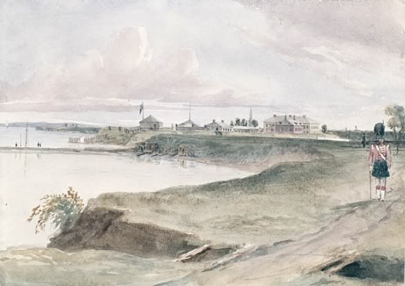
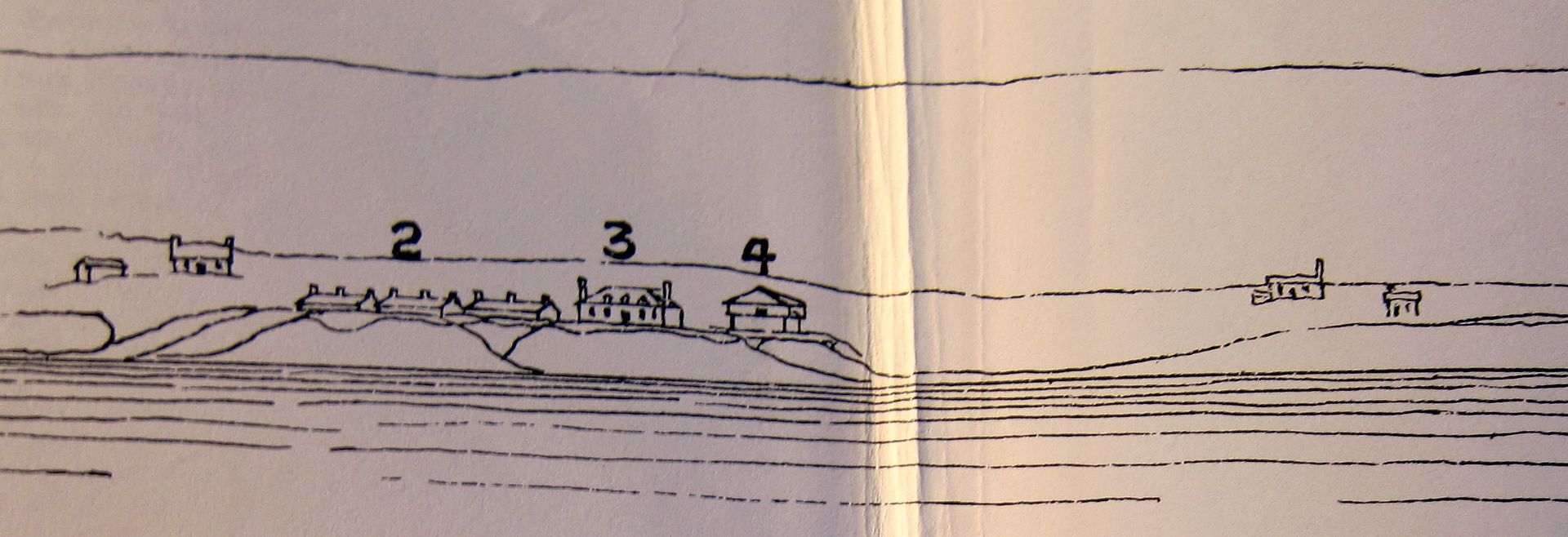
Robertson's Landmarks of Toronto , Vol. 3 p.94 flyout - The Town of York (Toronto), Upper Canada (Ontario) in 1820. Was the Wheat Sheaf the closest tavern to Fort York? No! It was the Rescue Inn (far right). , Vol. 3 p.94 flyout - The Town of York (Toronto), Upper Canada (Ontario) in 1820. Was the Wheat Sheaf the closest tavern to Fort York? No! It was the Rescue Inn (far right). |
The above pen and ink sketch is from a tracing of an oil painting by a Scotch artist named Irvine, depicting an early view of York. Robertson gives this description of the two buildings on the far right:
"The first building east of the Garrison Creek, not numbered, is apparently a one-storey building, with one chimney, occupied about the site of the red brick house built by the Hon. J.H. Dunn, receiver general of Upper Canada, and afterwards occupied by Mr. (Sir) D.L Macpherson. … The Massey works now occupy the ground.
The small building immediately to the west (sic) of this, also unnumbered, was a tavern, which stood on the north side of Front street, at the north-east corner of what is now Bathurst. It was long frequented by the soldiers stationed in the fort. It was known for years as the Rescue Inn, and had a sign descriptive of a mother rescuing her child from an eagle's nest in the mountains."
Have you ever been swept up by the urge to go for a beer after climbing at Rock Oasis? It turns out that drinking, socializing, and having a good time is historically linked to the corner!
Note: Robertson’s labeling of the sketch is perhaps inaccurate with respect to the date. His account was written in 1895, and relied on the recollections of several third parties. The sketch was in fact a subsequent tracing of Irvine’s original painting, with modifications. The available evidence suggests the Rescue Inn was established in the early 1840s, rather than 1820.
 |
The Harbour of Toronto and Adjoining Coast,
by Sandford A. Fleming, 1851
The 1842 Cane map does not show this building. |
Elsewhere in
Landmarks, Robertson adds further detail to his coverage of the tavern -- and his description of the sign will astonish you:
"Another well-known Front street tavern […] was the Rescue Inn, a little to the east of the foot of Bathurst street, kept in the fifties by Mrs. Hickman. The most noticeable feature in connection with the Rescue tavern was its conspicuous signboard, which was noticeable not only for its great size, but for the wonderful and sensational style of its drawing.
The subject was the rescue of her infant by a mother from the nest of some enormous eagles in a rocky pass at the head of some apparently inaccessible mountains. How the woman had climbed the mountains was a mystery, and how she was going to descend them was even more mysterious still.
But the sign served one good purpose, at any rate, and that, so far as the proprietor was concerned, was the chief one: it drew attention to the house and custom to its proprietor. So long as the Rescue was in existence it was a favourite resort for the troops stationed at the Old and New Forts, and it was always the first place a picquet made for when soldiers were reported as being absent from "tattoo." Like so many more of the old time places, this inn long since disappeared, and is now (1895) only remembered by those who lived in or had business associations with the neighbourhood."
Imagine that -- climbing at the Rock Oasis, even before it existed!
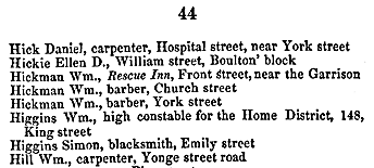
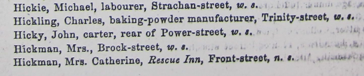
The Hickmans establish the Rescue Inn -- 1840sIt is in the 1843
Toronto Directory and Street Guide by Francis Lewis that we find the first mention of the Rescue Inn, on
“Front street, near the Garrison”:
 |
| 1843 Toronto Lewis Directory listing for the Rescue Inn |
 |
| The corresponding listing for Hickman |
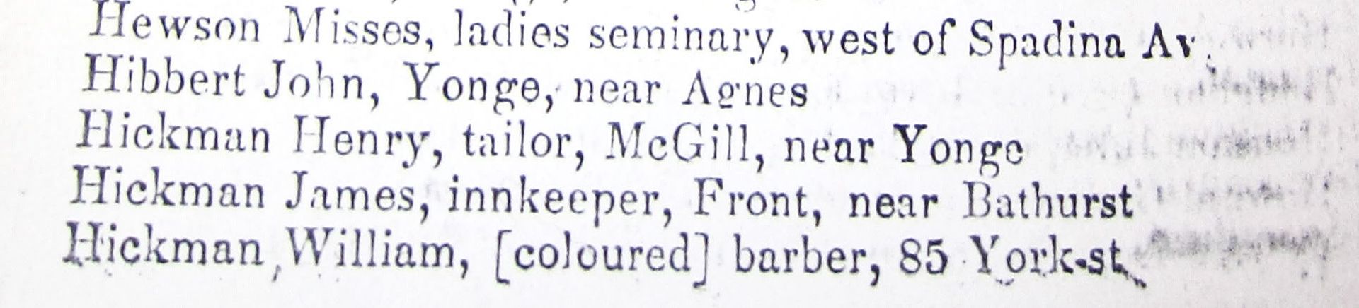
The listing identifies a Wm. Hickman as the proprietor. This appears to be a transcription error by Lewis -- George Brown’s 1846 directory lists
James Hickman as the owner of the Rescue Inn.
[The other Hickman family at that time in Toronto was led by William Hickman (Church St.), a black barber who came to Toronto from Virginia in the early 1830s. He had fought on the American side in the War of 1812 and been freed, but former slaves were not permitted to stay in Virginia. According to
The underground railroad: next stop, Toronto!
, this Hickman played an active role in the city’s early anti-slavery activities. His son (York St.) and grandson were also also named William, which may have contributed to confusion on Lewis’ part]
 |
| 1846 Brown’s Directory listing for James Hickman |
James Hickman operated the Rescue Inn through the late 1840s and early 1850s. He and his wife Catherine had a son in 1843 -- James Henry Hickman -- who would later partner with Captain Solomon Sylvester; a former wharf at the foot of Church St. was once named after their mutual enterprise.
James Hickman (Sr.) died in 1855. The widowed Catherine -- the
“Mrs. Hickman” referred to by Robertson -- consequently took over the Rescue Inn for a number of years, until 1858.
 |
| 1856 WR Brown Directory listing for Catherine Hickman |
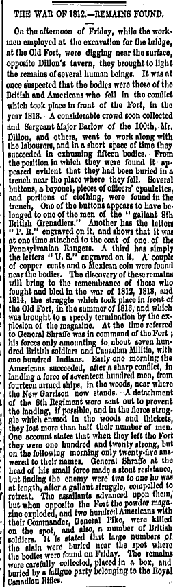
Remains found from War of 1812 - Dillon's tavernOn August 13, 1860,
The Daily Globe reported a grisly discovery
"opposite Dillon's tavern" -- which was actually the Rescue Inn, but under a new manager, William Dillon (the Assessment Rolls list Archibald Taylor as the owner of the property):
 |
| Aug. 13, 1860 Daily Globe report of 15 bodies found 'opposite Dillon's tavern' |
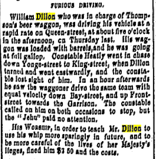
A William Dillon had previously been cited for
‘Furious Driving’ in June of 1858. It’s entirely possible that he was, in fact, rushing to get beer delivered to the Rescue Inn -- the description notes that Dillon drove at full gallop
‘up Front street towards the Garrison’.
 |
| June 7, 1858 Globe report of Dillon’s Furious Driving |
 |
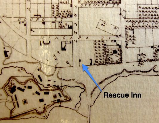
1858 Map of the City of Toronto extract, WS / HC Boulton,
via Ontario's History in Maps , showing the Rescue Inn's location. , showing the Rescue Inn's location.
The map's colour key tells us the Rescue Inn was a wooden edifice. |
Comparing Boulton’s 1858 version to the previous 1851 Fleming map, notice how the structure seems to have an additional section. This may account for the curious entry in the 1859 WCF Caverhill directory for William Dillon:
 |
| Is 426½ Front the extra section? |
Does the 426½ Front listing represent this additional section?
And is the 2nd William Dillon his progeny (notice he’s listed on Niagara St.)? Which of them was the Furious Driving Dillon?
Mrs. Hickman had moved on to a residence on High Street, according to the same Caverhill directory. Her young son (still 15 in 1858) was apparently not ready (or legally able) to assume the reins of the establishment, and as a result, the Rescue Inn passed through a number of hands over the following decade.
Mr. Dillon ran the Rescue Inn until 1860, when Valentine Caldwell (a widower lumber merchant, as well as a former member of the Queen’s Light Dragoons) took charge. In 1861 the name was modified to the ‘Rescue Hotel’, and it was run by Francis Loader. In 1863 George Steel and Mrs. Sarah Orpen were the innkeepers; they were followed by Samuel L. Bedson in 1865.
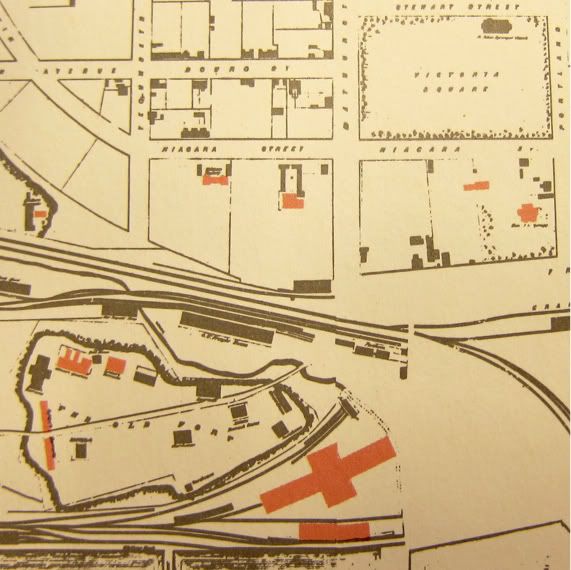
The Queen’s Wharf Hotel |
1876 Fisher directory Listing for
Edward Williams. Note P Burns entry. |
In 1867, Edward Williams took control of the establishment, and he changed the name to the Queen’s Wharf Hotel -- the Queen’s Wharf lay at the foot of Bathurst only a few hundred meters to the south. Williams proved to be rather more persistent than the previous innkeepers; he would successfully run the renamed tavern for the next ten years. (Interestingly, the street number for the tavern would change over this time period, from 426 to 500 Front St. W; later this address would become 580 Front.)
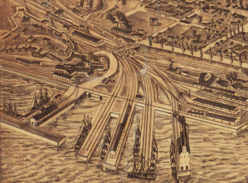
This sketch from 1876 shows the Queen’s Wharf (bottom left), Old Fort York, and the Northern Railway piers (bottom right) that would be used later on by the
Doty and
Bertram shipworks.
On the north east side of Front and Bathurst, you can discern a couple of small buildings. One of these is almost certainly the Rescue Inn -- or rather, the Queen’s Wharf Hotel.
After Williams came Abram Orpen in 1877 (perhaps related to Sarah Orpen? Could it even be the Abram Orpen of
racetrack fame?), then H Bennett in 1878.
Finally, in 1881 Michael Donnelly took over, and renamed the place the Eagle Hotel -- a hint, perhaps, that the old Rescue Inn sign might have still have been in use, with only the name changing over the years. This lasted for a couple of years, when in 1883 Donnelly apparently decided to call the tavern ‘Sherman House’. Donnelly continued to operate it until 1885.
The 1886 Polk directory lists the house as Vacant, and the structure remained unused until it was torn down somewhere around 1889 -- to make way for John Doty’s Engine Works. Over the years the Inn also shared the corner with several transient neighbours, including the Patrick Burns coal yard.
Like, Share, or Comment on this post!


